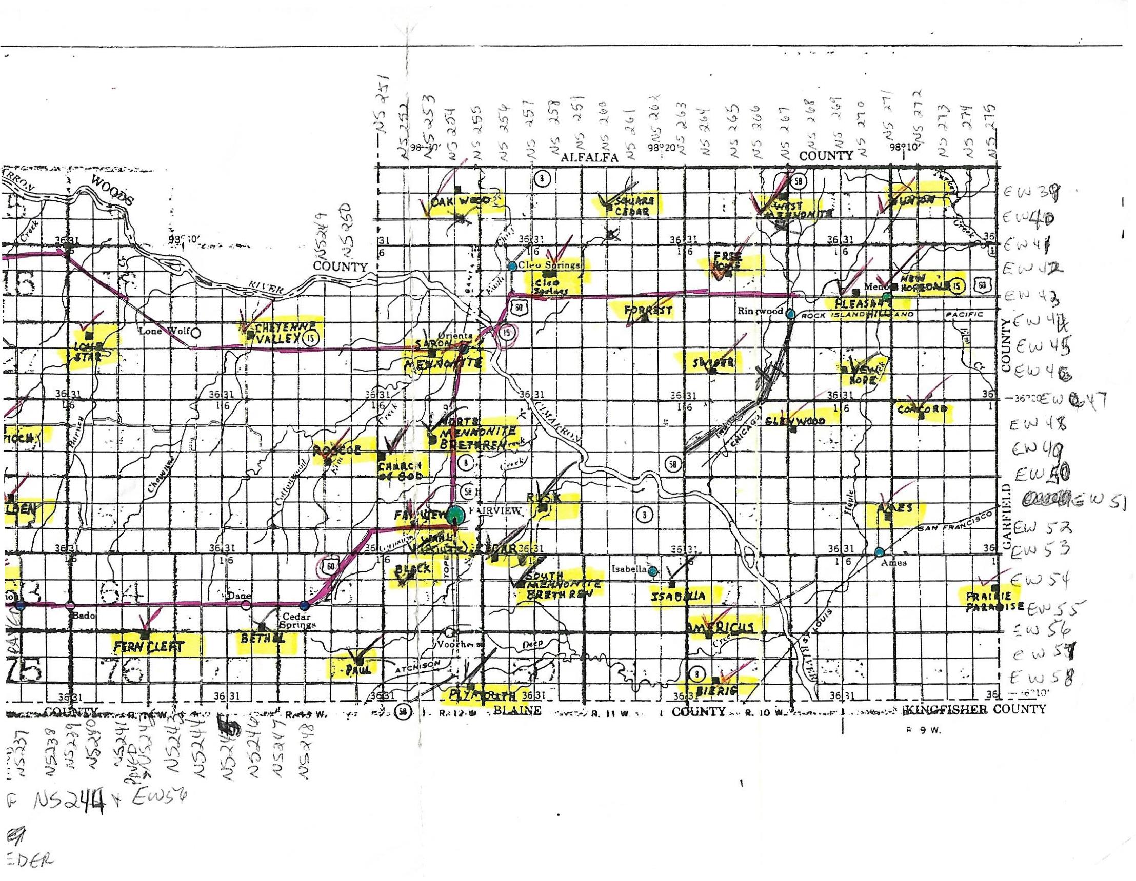
| Americus Cemetery | This cemetery is located from the intersection of U. S. Highway 8 and EW56, go east 1 mile
This cemetery has been abandoned. It is beside a barn and is littered with old farm machinery. No fences. | Complete Survey
Online, This Site |
| Ames | This cemetery is located east of Ames, from the corner of EW53 and NS271, go 1.5 miles north; cemetery opens on the west side of the road.
Markers in this cemetery have been photographed through November 2015 and posted. | Complete Survey Online, This Site |
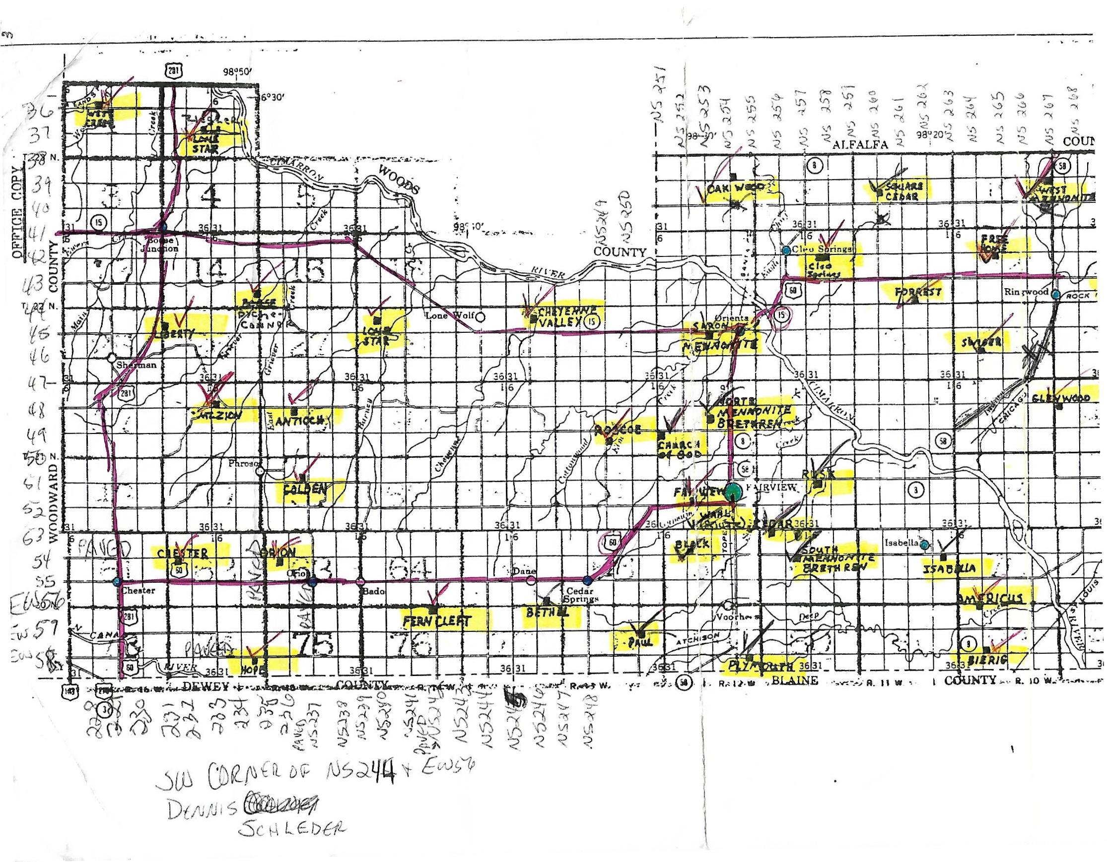
| Antioch | This cemetery is located from Fairview at the South junction of HWY 60 and HWY 58, on HWY 60 go west 18.3 miles to NS237, called the Orion corner, then go north 7 miles on NS237, then go west .5 miles; cemetery opens on the south side of the road.
Markers in this cemetery have been photographed through December 2016 and are posted. | Complete Survey
Online, This Site |
| Bethel | This cemetery is located from Fairview at the South junction of HWY 60 and HWY 58, on HWY 60 go 7.3 miles West just before Cedar Springs, go south on NS248 1 mile, then west on EW56 for 1.5 miles; cemetery opens on the north side of the road.
The markers in this cemetery are partially photographed through January 2017.
However, before we could get back to finish, there was a hugh ice storm that knocked down trees and messed up the the remaining cemetery. Once that gets cleaned up, we'll go back and finish. | Partial Survey
Online, This Site |
| Black | Cemetery is on private property; not photographed. | Partial Survey
Online, This Site |
| Bierig | This cemetery is located from the north side of Okeene (Blaine County) at the intersection of U.S. Highway 8 and E610 go north 3 miles to EW58, then east for 1 mile. Cemetery sits on the northeast corner of the intersection of NS264 and EW58.
Markers in this cemetery have been photographed through February 2016 and are posted. | Complete Survey
Online, This Site |
Cedar Cemetery
| This cemetery is located fom Fairview at the South Jct of HWY 60 and HWY 58 take HWY 58 and go South 1 mile then go East 1 ½ Miles.
Photographs of the markers in this cemetery are completed as of March 2016 and posted. | Complete Survey
Online, This Site |
| Chester | From Chester at the junction of HWY 281 & HWY 60, on HWY 281 go North 1 mile then go east on EW54 for 2.5 miles; cemetery sits on the south side of the road.
The markers in this cemetery have been photographed through October 2016 and posted. | Complete Survey
Online, This Site. |
| Cheyenne Valley | This cemetery is located from the intersection of HWY 60 and HWY 412 north of Fairview, go 8 miles west to NS246, turn north on NS246 for .5 miles; cemetery opens on the east side of this gravel road.
Photographs of the markers in this cemetery are complete through December 2016 and posted. | Complete Survey
Online, This Site |
| Church of God, aka Penner | This cemetery is located from the intersection of Highway 60 and EW49, approximately 2 miles north of Fairview, go west on EW49 for 3 miles; cemetery is on the southeast corner of EW49 and NS251.
Photographs of this cemetery are complete as of October 2016 and posted. | Complete Survey
Online, This Site |
| Cleo Springs | This cemetery is located from the intersection of HWY 8, aka 3rd Street, and Texas in Cleo Springs, go east 1.5 miles; cemetery opens on the right side of the road.
Photographs of this cemetery are complete as of October 2016 and posted. | Complete Survey
Online, This Site |
| Concord | This cemetry is located from east of Meno, from the intersection of U.S. Highway 60 and NS271/South Meno Avenue, go south on NS271 for 4 miles, then east on EW47 for 1 mile, then south on NS272 for .5 miles; cemetery is situated on the east side of the road.
Markers in this cemetery have been photographed through October 2015 and posted. | Complete Survey
Online, This Site |
| Conner | This cemetery is located from the junction of HWY 60 and HWY 58 north of Fairview, go west on HWY 412 for about 19 miles to NS236 /or/ from Bouse Junction, the junction of HWY 412 and HWY 281, just east of the western Major County border, go east for 5 miles to NS236, turn south on NS236 for 1.5 mies, then west on EW43 for 1 mile to the stop sign, then south on NS253.3 for about 1.2 miles, following the winding road; cemetery opens on the north side of the road.
Photographs of the markers in this cemetery are complete through November 2016 and posted. | Complete Survey
Online, This Site |
| Era, aka New Hope | This cemetery is located from S. Meno Avenue, which is also NS269 on the east side of Meno, go on NS269 south 3 miles to EW46 then go west 2 miles; cemetery on the northeast corner of this intersection.
Markers in this cemetery have been photographed through September 2015 and posted. | Complete Survey
Online, This Site |
| Fairview | From Fairview at the South Junction of HWY 60 and HWY 58 on HWY 60 go West 1.25 miles towards Chester.
Photographs of markers in this cemetery are through November 2016 and posted. | Complete Survey
Online, This Site |
| Fern Cliff | From Fairview at the South junction of HWY 60 and HWY 58, on HWY 60 go West 13.3 miles to NS242 then go South 1 mile; cemetery sits on the southwest corner of NS242 and EW56.
Photographs of the markers in this cemetery are complete through October 2016 and posted. | Complete Survey
Online, This Site |
| Forrest | This cemetery is located from Ringwood, from the junction of U.S. Highways 60 and 58, on U.S. Highway 60 go west 5 miles then turn south on NS262 for 1 mile, then west on EW44 for 1/2 mile; cemetery opens on the north side of the road.
Photographs of the markers in this cemetery are complete through August 2015 and posted. | Complete Survey
Online, This Site |
| Foster | Family Cemetery is on private property | Not Surveyed
|
| Free Home. aka Old Ringwood | This cemetery is located from the junction of U.S. Highway 60 and State Highway 58 at Ringwood, go north on State Highway 58 for 1 mile then go west on EW42 for 2.4 miles; cemetery opens on the north side of the highway.
Photographs of the markers in this cemetery are complete through August 2015 and posted. | Complete Survey
Online, This Site |
| Glenwood | This cemetery is located from the junction of State Highway 412/ U.S. Highway 60 and NS267, turn south through Ringwood for 5 miles to the intersection of NS267 and EW 48. Cemetery sits on the southeast corner of this intersection.
Photographs of the markers in this cemetery are complete through October 2015 and posted. | Complete Survey
Online This Site |
| Golden | This cemetery is located from Fairview at the South junction of HWY 60 and HWY 58, on HWY 60 go west 18.3 miles to NS235, the Orion corner, then go north on NS235 for 4 miles to EW51, then go west for about 100 yards; cemetery opens on the north side of the road.
Photographs of the markers in this cemetery are complete through December 2016 and posted. | Complete Survey
Online, This Site |
| Hope | This cemetery is located from Fairview at the South junction of HWY 60 and HWY 58, on HWY 60 go West 18.3 miles to NS237 then go South 3 miles then West on EW58 2 ¼ miles; cemetery opens on the south side of the road.
Photographs of the markers in this cemetery are complete as of October 2016 and posted. | Complete Survey
Online, This Site |
| Hurt | Cemetery is on private property; not photographed. | Partial Survey
Online, This Site |
| Isabella | This cemetery is located from the junction of HIghway 58/U.S. Highway 60 and south of Fairview, go south on Highway 58 for 2 miles to EW 54, then east on EW54 for 8.5 miles. Cemetery opens on the south side of the road.
Markers in this cemetery have been photographed through February 2016 and posted. | Complete Survey
Online, This Site |
| Liberty | This cemetery is located from Fairview at the North Jct of HWY 60 and HWY 58, on HWY 60 go North 6 mils to the Jct of HWY 60 and HWY 412 then on HWY 412 go West about 23 miles to the Jct of HWY 412 and HWY 281 then on HWY 281 go South about 4 miles then East ½ Mile.
Markers in this cemetery have been photographed through August 2014 and posted. | Complete Survey
Online, This Site |
| Lone Star | This cemetery located from the junction of HWY 60 and HWY 412 north of Fairview go west on HWY 412 for about 13 miles to NS241, then south on NS241 for 1 mile to EW44, then west on EW44 for 1 mile then south for .25 miles; cemetery opens on the west side of the road.
Markers in the cemetery have been photographed through November 2016 and posted. | Complete Survey
Online, This Site |
| Miscelaneous Obits | On Line -- This Site | Various Submitters |
| Mennonite Brethren North | This cemetery is located from Fairview at the north junction of U.S. Highways 60 and 58, go north on U. S. Highway 60 for 2 miles, then go west on EW49 for 1 mile, then north on NS253 for .5 miles; //or// From Orienta, go south on U.S. Highway 60 for 4 miles, then west on EW49 for 1 mile, then north on NS 253 for .5 miles; cemetery opens on the east side of the road.
Markers in this cemetery have been photographed through August 2015 and posted.Complete Survey
Online, This Site | |
| Assorted Obits | | Various Submitters |
| Mount Zion | This cemetry is located from Fairview at the South junction of HWY 60 and HWY 58, on HWY 60 go West 18.3 miles to NS237, the Orion corner, then go north on NS237 for 7 miles to EW48, then go west on EW48 for 3 miles; cemetery is about .25 miles past the paved corner on EW48, on the north side of the road.
Markers in this cemetery have been photographed through December 2016 and posted. | Complete Survey
Online, This Site |
| New Hopedale, aka Mennonite Cemetery | This cemetery is located from the intersection of U. S. Highways 60 and 412 and NS271 in Meno, turn north on NS271 for 1 block; cemetery is on the east side of the road.
Markers in this cemetery have been photographed through August 2015 and posted. | Complete Survey
Online, This Site |
| Oakdale, aka Swiger | This cemetery is located from north of Ringwood at the junction of highways 60 and 58, go west 3 miles on highway 60 to NS264, then south on NS264 for 3 miles; cemetery is located on the northeast corner of this intersection.
Markers in this cemetery have been photographed through August 2015 and posted.Complete Survey
Online, This Site | |
| Orion | This cemetery is located from Fairview at the south junction of HWY 60 and HWY 58, on HWY 60 go West 20.2 miles to NS237, AKA Orion Corner, then go north 1 mile then go west on EW54 for 1 mile; cemetery opens on the south side of the road.
The markers in this cemetery have been photographed through December 2016 and posted. | Complete Survey
Online, This Site |
| Paul | Cemetery is on private property; not photographed. | Partial Survey
Online, This Site |
| Pioneer, aka Oakwood | This cemetery is located from Cleo Springs on HWY 8 go North 3 miles then go West 3 miles; cemetery is located on the northwest corner of the intersection of EW39 and NS254.
The markers in this cemetery have been photographed through November 2016 and posted. | Complete Survey
Online, This Site |
| Pleasant Hill | This cemetery is located from Ringwood at the junction of U.S. Highway 60 and U. S. Highway 58, on U. S. Highway 60 go East 2 ½ miles. Cemetery opens on the north side of the highway. If coming from the east, from Meno Avenue in Meno, go west on U. S. Highway 412/60 for 1.5 miles.
Markers in this cemetery have been photographed through August 2015 and posted. | Complete Survey
Online, This Site |
Pleasant Prairie
aka Wildwood Cemetery | This cemetary is located from the east side of Ames at the intersection of roads NS271 and EW53, go east 4 miles to NS275, then go south 1 1/4 miles. Cemetery opens on the west side of the road.
Markers in this cemetery have been photographed through August 2015 and posted. | Complete Survey
Online, This Site |
| Plymouth | This cemetery is located from Fairview, OK on Hwy 58 go South about 6 miles to the junction of Hwy 51A. On Hwy 51A go South to the first corner going East about 1/2 mile. Then go East on EW58 about 1/2 mile. Cemetery is on the South side of the road.
Markers in this cemetery have been completed as of March 2016 and posted. | Complete Survey
Online, This Site |
| Roscoe | This cemetery is located from Fairview at the north junction of HWY 60 and HWY 58, on HWY 60 go north 2 miles to EW49, then west on EW49 for 5 miles to NS249, then south on NS249 for .5 miles; cemetery opens on the east side of the road.
Photographs of the markers in this cemetery are complete through December 2016 and posted.Complete Survey
Online, This Site | |
| Rusk | This cemetery is located from Fairview at the north junction of U. S. Highways 60 and 58, on U. S. Highway 58 go east on EW51 for 3.5 miles; cemetery opens on the south side of the road.
Markers in this cemetery have been photographed through November 2015 and posted. | Complete Survey
Online, This Site |
| Saron Mennonite Church | This cemetery is located from Orienta, at the junction of U.S. Highways 60 and 412, go west on U.S. Highway 412 for 1 mile; cemetery sits on the southeast corner of the intersection of NW253.
Markers in this cemetery have been photographed through August 2015 and are posted. | Complete Survey
Online, This Site |
| Sorge | Cemetery is on private property; not photographed. | Partial Survey
Online, This Site |
| South Mennonite Brethren | This cemetery is located from Fairview at the South Junction of HWY 60 and HWY 58, on HWY 58 go South 2 miles then go East 2 ½ Miles
Markers in this cemetery have been photographed through March 2016 and posted. | Complete Survey
Online, This Site. |
| Square Cedar, aka Oak Grove | This cemetery is located from State Highway 8, go 1 mile north of Cleo Springs to EW41, then east on EW41for 3 miles to NS260, then north on NW260 for 1.5 miles; cemetery opens on the east side of the road.
Markers in this cemetery have been photographed through September 2015 and posted. | Complete Survey
Online, This Site |
| Union | This cemetery is located from the intersection of U.S. Highway 60 and NS271 on the east edge of Meno, go north for 3.5 miles on NS 271; cemetery is on the east side of the road; in September 2015, it is completely overgrown.
Markers in this cemetery have been photographed through August 2015 and posted. | Complete Survey
Online, This Site |
| West Creek | This cemetery is located from Bouse Junction, the junction of HWY 412 and HWY 281, just east of the western Major County border, go north 5 miles to EW36, then then go west on EW36 for 3 miles on this paved road; cemetery opens on the north side of the road.
Markers in this cemetery have been photographed through November 2016 and posted. | Complete Survey
Online This Site |
| West New Hopedale aka West Mennonite | This cemetery is located from the intersection of U. S. Highways 60 and 412 and State Highway 58 (north of Ringwood or west of Meno), go 4 miles north to the intersection of State Highway 58 and EW39; cemetery opens on the southwest corner of this intersection.
Markers in this cemetery have been photographed through August 2015 and posted. | Complete Survey
Online, This Site |
| Zeigler Lone Star | This cemetery is located from Bouse Junction, the junction of HWY 412 and HWY 281, just east of the western Major County border, go north 5 miles to EW36, then then go east on EW36 for 1.5 miles around the corner and further south for another 1 mile, then west into a section on a farm road for about .5 miles.
Markers in this cemetery have been photographed through November 2016 and posted. | Complete Survey
Online This Site |
Major County
Funeral Homes |
On Line This Site |
Online This Site |