

 |
 |  |

=====================
State pf Oklahoma |
| SS::
County of Ellis
|
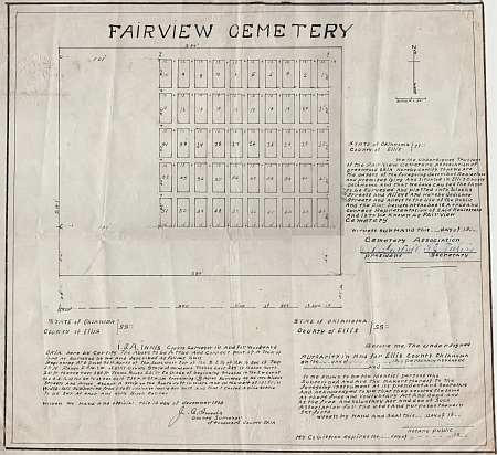
We the undersigned trustees of the FairView Cemetery association of greenwood
Okla Hereby certify that we are the owners of the foregoing described real
estate and premises lying and situated in Ellis county Oklahoma and that we have
caused thesme to be surveyed and platted into blocks streets and alleys and
hereby dedicate streets and alleys to the use of the public and the plat hereto
attached is a true and correct representation of said real estate and is to be
known as FairView Cemetery
( Jan )
Witness our hand this ( 27 ) day of 19 ( 09 )
Cemetery Association
(signed) (O D Gartrell)
signed (I J Teeters)
president secretary
=====================
State pf Oklahoma |
| SS::
County of Ellis
|
I. J.A. Innis County surveyor in and for Woodward Okla. hereby certif;y the above to be a true and correct plat of a tract of land as surveyed by me and described as follows To Wit
Beginning at a point 33ft North of the South West Cor of the S. E. 1/4 of
the S. W 1/4 Sec 12 Twp 23 N Range 23 W. I.M. of Ellis County State of Oklahoma
thence East 289' ft thence North 241 ft thence West 289 ft thence South 241 ft
to place of beginning situated in the S. W cor of the S. E. 1/4 of the S. W 1/4
of Sec No 12 T.25 N. R. 23 W. I.M. containing 1 62/100 Acres surveyed by me into
Blocks and Streets and Alleys except a strip in the South 54 ft in width and on
the west of 101 ft in width. lots numbering from 1 to 51 inclusive leaving out
no 13 and that I caused a pine stake to be set at each and every Block corner
Witness my hand and official this 14 day of December 1908
(signed) J. A. Innis
county Surveyor
Of Woodward County OKla
======================
State pf Oklahoma |
| SS::
County of Ellis
|
Before me the undersigned Authority in and for Ellis county Oklahoma on the (27)
day of ( January ) 19 ( 09 )
personaly appeared ( O D Gartrell ) and (
I J Teeters )
to me known to be the
identicl persons who Subscribed and are the makers thereof to the foregoing
instrument as its president and secretary and acknowedged to me that they
xecuted the same as there free and voluntary act and dee of such asociation for
the uses and purposes therein set forth
( January )
witness my hand and sseal this (
27 ) day of 19 ( 09
)
(signed) ( Jennie Casey )
notary public
My commission expires the (
9 ) day of
( May ) 19 ( 12 )
This site may be freely linked, but not duplicated in any way without consent.
All rights reserved! Commercial use of material within this site is prohibited!
© 2000-2026 Oklahoma CemeteriesThe information on this site is provided free for the purpose of researching your genealogy. This material may be freely used by non-commercial entities, for your own research, as long as this message remains on all copied material. The information contained in this site may not be copied to any other site without written "snail-mail" permission. If you wish to have a copy of a donor's material, you must have their permission. All information found on these pages is under copyright of Oklahoma Cemeteries. This is to protect any and all information donated. The original submitter or source of the information will retain their copyright. Unless otherwise stated, any donated material is given to Oklahoma Cemeteries to make it available online. This material will always be available at no cost, it will always remain free to the researcher.