The land that was to become the State of Oklahoma was a portion of the Louisiana Purchase. In 1803, U.S. President Thomas Jefferson purchased 828,000 square miles of the French Territory of Louisiana from Napoleon Bonaparte for $15,000,000 -- $0.03 per acre. Eventually, Oklahoma would occupy 69,898 miles, about 8.4% of the area, thus costing about $1,300,000. This purchase allowed for the western expansion of the young nation.
 Louisiana Purchase 1803
|
At the time, powerful political people and southern plantation owners wanted to move the Native Americans out of the southeastern portion of the country in order to increase the size of their cotton plantations. The landowners got their wish when in 1830, President Andrew Jackson signed into law the Indian Removal Act, allegedly to remove the Native Americans "voluntarily" -- however, "removal" quickly became "forced relocation". The area to which the Native Americans were moved later became Oklahoma.
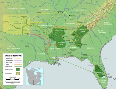 Trail of Tears
|
The Chocktaw Nation were the first to be moved into the Indian Territory beginning in 1831; they were living and farming in Alabama, Mississippi and Louisiana. A Choctaw chief was quoted as saying that the removal was "a trail of tears and death" (the infamous "trail of tears").
Removed next were the Seminoles in 1832 (out of Florida), followed by the Creek in 1834 (out of Alabama and Georgia), the Chickasaw in 1837, and finally the Cherokee in 1838. These relocations opened approximately 25,000,000 acres of land for predominently white settlement in the southeast.
Realizing that transportation was necessary to settle all this land west of the Mississippi River, in 1859 Congress gave the Atchison, Topeka and Santa Fe Railroad specific routes through the area and they began building railroads.
In order to further motivate people to populate these lands, in 1862 President Lincoln signed into law the Homestead Act, granting individuals a claim to 160 acres of land (a quarter section). Using the Public Land Surveying System, the government surveyed the Indian Territory into claims (160 acres), sections (640 acres), and 36 sections (6 miles by 6 miles square) into a township -- this plat system remains in affect today.
During treaty negotiations with the U.S. Government, Choctaw Chief Allen Wright suggested the name "okla humma" (Choctaw for "red man") for their occupied area; this Chief envisioned an entire state populated solely by "red men" (Indians). However, in 1887, Congress adopted the Dawes Severalty Act which authorized President Grover Cleveland to survey Indian tribal land and divide it into allowments for individual indians at 160 acres per head-of-household (a claim), and allowing that the excess land (approximately 90,000,000 acres) be opened for settlement by non-indians.
The name Oklahoma (Indian) Territory was officially adopted in 1890. By that time, more than 30 Native American Tribes and Nations had been "relocated" into the Territory.
Before the excess lands were released by the government for homesteading, there was a strong political group of farmers calling themselves "Boomers" who believed that they could occupy the land under the Homestead Act. These "Boomers" were constantly being removed from the land by the U.S. Army. Finally, in 1889 Congress authorized the first of 7 land runs for homesteading to populate the area. Farmland was not the only homesteads offered -- towns (within townships) were divided into "lots" which could also be homesteaded for future businesses. For example, one town in particular, Guthrie Station, which would become Oklahoma's first Capitol, was literally built in a day. On the morning of April 22, 1889, there was nothing but deer and coyotes -- by nightfall, there were houses, streets and a city of 10,000 people!
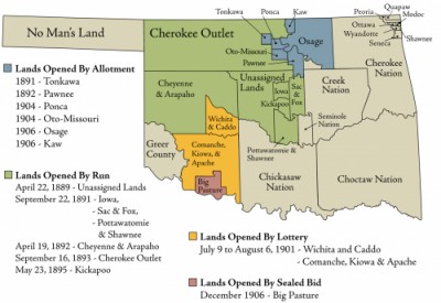 Oklahoma Land Openings
|
Seven land runs took place in Oklahoma (Indian) Territory as follows:
1. Land Run of April 22, 1889: Land run of 1889 took place at high noon and involved the settlement of the Unassigned Lands (most of modern day Canadian, Cleveland, Kingfisher, Logan, Oklahoma, and Payne counties).
2. Land Run of September 22, 1891: Land run to settle Iowa, Sac and Fox, Potawatomi, and Shawnee lands.
3. September 23, 1891: Land run to settle Tecumseh, the pre-designated location of the county seat of County B, later renamed as Pottawatomie County.
4. September 28, 1891: Land run to settle Chandler, the pre-designated location of the county seat of County A, later renamed as Lincoln County.
5. Land Run of April 19, 1892: Land run to settle the Cheyenne and Arapaho lands.
6. Land Run of September 16, 1893: Cherokee Outlet Land Run. The Run of the Cherokee Strip opened 8,144,682.91 acres (12,726 square miles or about 3.3 million hectares) to settlement on September 16, 1893. The land was purchased from the Cherokees for $8,595,736.12. This was largest land run in United States history, four times larger than the land run of 1889. The Cherokee Strip Regional Heritage Center museum at the eastern edge of Enid, Oklahoma commemorates this event.
7. May 23, 1895: Land run to settle the Kickapoo lands.
Those who left the day or night before the actual opening of these runs, avoiding the army patrols to file claims, were called "sooners" -- combine with the homesteaders who tried to occupy land before the government opened it, the "Boomers", and you have the Oklahoma University's football team's fight song: "Boomer Sooner"
Imagine, if you can, being a farmer in Europe, or the southern United States, where all the land is owned by the wealthy land lords -- you "share crop" the land, you NEVER own it. Suddenly before you appears "manifest destiny"! Your hard work will be rewarded with ownership!
Beginning in 1896, the final lands were added to the Oklahoma (Indian) Territory creating the boundaries for the present State of Oklahoma.
1. Greer County was officially assigned by a U.S. Supreme Court decision, separating it from Texas, on March 16, 1896
2. The Comanche, Kiowa and Apache reserve was distributed through land lotteries, June 9 through August 6, 1901.
3. The Wichita and Caddo reserve was also distributed through land lotteries, June 9 through August 6, 1901.
4. The Ponca and Otoe-Misouria reserve was distributed through allotment in 1904.
5. The Kaw reserve was distributed through allotment in 1906.
6. The Osage reserve was also distributed through allotment in 1906.
7. Big Pasture was distributed through sealed bid in December 1906.
The boundaries of the Oklahoma Territory were thus established and the Territory was soon to become the State of Oklahoma. The days of prosperity were upon the homesteaders, plow the land (they were called "sod busters"), raise the crop, harvest and sell the crop, buy more land, support the local businesses, repeat consistently!
As the homesteaders settled into their daily activities, they found the need to govern themselves. Since the land had been divided into townships, each township formed loose government units. Having learned from the "black plague" (15th through 20th centuries) and other deadly, infectuous diseases, that the dead must be buried, one of the government's earliest actions was to form a cemetery. Most of Oklahoma's cemeteries were formed in the late 1800's. A plat map of a county, with cemeteries identified thereupon, shows that in rural Oklahoma, there was normally one cemetery per township. The larger populated areas, of course, expanded as needed, purchasing land where available. As a Statehood Centennial Project completed in 2005, the Oklahoma Home and Community Education, Inc., compiled and printed such maps for each of Oklahoma's 77 counties. This publication is normally available in the Library at each of the county seats.
The following quotes are from a play written to re-enact the celebration of the Territory's admission to statehood in 1907 and included the following characters:
Frank Greer, editor and publisher of the Oklahoma State Capital.
Kentucky Daisy, newspaper reporter.
Marian Tuttle Rock , author of The Illustrated History of Oklahoma.
Helen Candee, reporter for The Forum, a popular magazine of the time.
Dr. Hugh Scott , private secretary of Territorial Gov. Frank Frantz.
Charles Filson, Territorial Secretery, read Pres. Roosevelt's Statehood proclamation.
Charles G. Jones of Oklahoma City represented Mr. Oklahoma Territory in the wedding.
Mrs. Anna Bennett represented Miss Indian Territory in the wedding.
Rev. Dodson , pastor of the First Baptist church of Guthrie, performed the mock wedding.
William Durant, Sergeant-at-Arms of the Consitutional Convention, gave away the bride.
Charles Haskell was the Governor Elect.
Mrs. Haskell was the wife of the governor.
Leslie Niblack, editor of the Guthrie Daily Leader and a justice of the peace administered the oath of office to the Governor.
Judge Frank Dale, Chief Justice of the Territorial Supreme Court, served as Master of Ceremonies.
"The following proclamation was signed by President Theodore Roosevelt at 10:16 a.m. Eastern Standard Time, today at the White House in Washington, D. C.:
'I Theodore Roosevelt, President of the United States of America, do in accordance with the provisions of the said act of Congress, declare and announce that the state of Oklahoma is to be deemed admitted by Congress into the Union on an equal footing with the original states. Done at the city of Washington this 16th day of November in the year of our Lord, 1907.'
Then, in further celebration came the (mock) marriage ceremony which joined Oklahoma and Indian Territory for life.
Charles G. Jones of Oklahoma City, for many years one of the most tireless champions of joint statehood, was the groom and made the proposal of marriage to the bride, Miss Indian Territory, who was Cherokee and played by the wife of the United States Marshal at Muskogee.� The marriage was performed and the official oath was administered to Governor Haskell at 12:20."
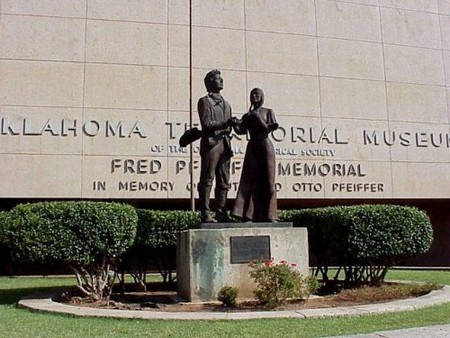 Mock Wedding, submitted and © John Lehr
|
The 46th state of the United States of America was created.
|Home|
This site may be freely linked, but not duplicated in any way without consent.
All rights reserved! Commercial use of material within this site is prohibited!
© 2000-2026 Oklahoma Cemeteries
The information on this site is provided free for the purpose of researching your genealogy. This material may be freely used by non-commercial entities, for your own research, as long as this message remains on all copied material. The information contained in this site may not be copied to any other site without written "snail-mail" permission. If you wish to have a copy of a donor's material, you must have their permission. All information found on these pages is under copyright of Oklahoma Cemeteries. This is to protect any and all information donated. The original submitter or source of the information will retain their copyright. Unless otherwise stated, any donated material is given to Oklahoma Cemeteries to make it available online. This material will always be available at no cost, it will always remain free to the researcher.