[an error occurred while processing this directive]
Liberty Cemetery
Alfalfa County, Oklahoma
 ©Glenn
|
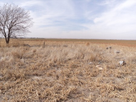
Liberty Cemetery is located 5 and 1/2 miles west and 2 and 1/2 miles south of the intersection of Burlington and Highway 11 /or/ from the intersection of U. S. Highway 64, and State Highways 8, 11 and 58, go north on State Highways 11 and 58 for 5 miles, then west on Johnson Road for 9 miles, then north 1/2 mile; cemetery is in the middle of a section, in a cultivated wheat field, west of the dirt road. There are currently (2012) no stones left standing, they have been totally or partially destroyed.
The following used with permission, Cherokee Strip Volunteer League, "Alfalfa County Oklahoma Cemeteries": Liberty Cemetery is located in Section 31 Township 28N Range 12W in Alfalfa County. The cemetery was located west of the Liberty Friends Church in the NE quarter and together they included two acres. It is no longer used and several bodies have been moved to cemeteries with perpetual care. The church building has been moved. The map is recorded at Alfalfa County courthouse in plat book 4 page 2.
As you can see by these photographs, there's little left at this cemetery; if you have any information about burials in this cemetery, please contact area coordinator.
| LOT NO. |
LAST NAME |
FIRST NAME |
BIRTH |
DEATH |
NOTES |
| |
Allen |
Amelia M. |
02-28-1835 |
07-31-1901 |
See more |
| |
Allen |
Ervin |
08-10-1830 |
12-19-1908 |
See more |
| |
Brown |
America |
06-14-1828 |
02-24-1900 |
See photo |
| |
Floyd |
Infant Son |
07-31-1903 |
08-05-1903 |
See photo |
| |
Floyd |
John L. |
Dec. 22, 1884 |
April 15, 1906 |
See photo |
| |
Gish |
Iva M. |
03-07-1895 |
03-03-1906 |
See photo |
|Alfalfa County Page| |Home|
[an error occurred while processing this directive]