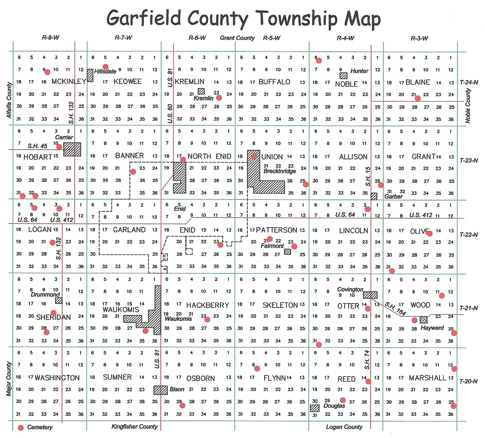
Baumagartner Cemetery
aka Wesley M. E. Chapel |
From the intersection of State Highways 132 and 45, go 3 miles south on State Highway 132 then west on Willow for 2.5 miles. Cemetery opens on the south side of the road.
Potographs are complete as of 2013 and posted.
Complete Survey
Online This Site |
|
Black Bear Cemetery,
aka Baldwin Cemetery |
This cemetery is located on the farm that belonged to Elias Henry BALDWIN, it is in Olive twns Sec. 15, T 22 North, R 3 West. From the intersection of U.S. Highway 412 and State Highway 74 south of Garber, go 1.5 miles south on State Highway 74 to Rupe Road, turn east on Rupe Road for 4.5 miles; cemetery opens on the north side of the road.
Photographs are complete as of August 2014 and posted. |
Complete Survey
Online This Site |
| Bethany Cemetery |
Bethany Cemetery is located in Enid twns, Sec. 23, T 22 North, R 6 West. From the intersection of U.S. Highway 81 and Southgate Road, go east on Southgate road for 4.5 miles; cemetery opens on the north side of the road.
Photographs are complete as of January 2015 and posted. |
Complete Survey
Online This Site |
| Bethel Cemetery |
This cemetery is located from the intersection of State Highways 74 and 164 on the south side of Covington, go 5 miles south on State Highway 74 to Reed Road, then west on Reed Road for less than 1/4 mile; Cemetery is on the south side of the road.
Photographs are complete as of November 2014 and posted.
Complete Survey
Online This Site |
|
| Bison Cemetery, aka St. Joseph Catholic Cemetery |
Bison Cemetery is located in T 20 North, range 6 west, Sec. 29 in Osborn twns. From the intersection of U. S. Highway 81 and Marshall Road, 1.5 miles south of Bison, turn east on Marshall road for 1 mile; cemetery opens on the north side of the road.
Photographs are complete as of January 2015 and posted. |
Complete Survey
Online This Site |
| Breckinridge Lutheran Cemetery, aka Immanuel Lutheran Cemetery |
This cemetery is located from the intersection of U. S. Highway 412 and 90th Street east of Enid, go north for 4.5 miles. Cemetery sits on the northwest corner of that intersection.
Photographs are complete as of March 2015 and posted.
Complete Survey
Online This Site |
|
| Calvary Catholic Cemetery |
This Cemetery is located at the corner of Willow and Grand, Enid, OK. Volunteer photographers needed to take
tombstone photos at this cemetery.
If interested please e-mail: Area Coordinator |
Partial Survey
Online This Site |
Chisholm Trail Burial Park
This cemetery is located @7624 N. 54th Street, Enid, Travelling North on Highway 81. Turn right (east) onto Hwy 45 and travel 4 1/2 miles. Chisholm Trail Burial Park will be on the North side (left) of the road
Potographs are complete as of 2013 and posted.
Complete Survey
Online This Site |
| |
Collett Cemetery
This cemetery is located from the intersection of U.S. Highway 412 and 114th Street east of Enid, go south on 114th Street for 2 miles; cemetery opens on the east side of the road.
Photographs are complete as of January 2015 and posted.
Complete Survey
Online This Site |
| |
Coldwater Cemetery
This cemetery is located 1 mile north of Hillsdale, 2 miles west.
Photographs are complete and posted.
Complete Survey
Online This Site |
| |
| Covington Cemetery |
This cemetery is located 1/2 mile South of Covington, OK on State Highway 74.
Photographs completed and posted |
Complete Survey
Online This Site |
| Del Norte Cemetery |
This cemetery is located 1mile South and West of Drummond , OK .
Photographs complete through February 2015 and posted
|
Complete Survey
Online This Site |
| Douglas Union Cemetery |
This cemetery is located in Otter twns. Sec. 31, T 21 North, R 4 West. From the intersection of State Highways 74 and 164 on the south side of Covington, go south on State Highway 74 for 3 miles to Flynn Road, then west on Flynn Road for 4.25 miles; cemetery opens on the south side of the road.
Photographs completed through January 2015 and posted. |
Complete Survey
Online This Site |
| Enid Cemetery |
This cemetery is located on West Willow just West of Grand Ave., Enid, OK. On Line - This site
partial survey
Volunteer photographers needed to take
tombstone photos at this cemetery.
If interested please e-mail: area coordinator |
Partial Survey
Online This Site |
| First United Methodist Church Columbarium |
This facility is located at 401 W. Randolph, Enid, OK.
Partial Survey
Volunteer photographers needed to take
photos at this facility.
If interested please e-mail: area coordinator |
Partial Survey
Online This Site |
| Garber Cemetery |
This cemetry is located in Allison twns. Sec. 25, T 23 North, R 4 West. From the intersection of U.S. Highway 74 and Phillips Road on the northern edge of Garber, turn east on Phillips Road for 1 mile, then south for .3 miles; cemetery opens on the west side of the road.
Photographs completed through December 2014 and posted. |
Complete Survey
Online This Site |
| Garber Lutheran Cemetery |
This cemetery is located in Section 2, Lincoln twp Range 22 North and 4 West. From the intersection of U.S. Highway 412 and State Highway 74 south of Garber, go north on State Highway 74 for .5 miles to Chestnut, then left (west) on Chestnut for .5 miles; cemetery opens on the north side of the road.
Photographs complete as of August 2014 and posted. |
Complete Survey
Online This Site |
| Garfield County Cemeteries |
On Line - This site |
Submitted by Tammie Chada |
| Garfield County Funeral Homes |
On Line - This site |
Submitted by Tammie Chada |
German M. E. Cemetery
aka Ebenezer Cemetery |
This cemetery is located in Marshall twns. Sec. 25, T 20 North, R 3 West. From State Highway 164 and Noble Road aka County Road 10, west of Lucien or east of Hayward, go south on Noble Road for approximately 7 miles, then west on an unnamed dirt road for 1/2 mile; cemetery is on the north side of the road.
Photographs complete through October 2014 and posted. |
Complete Survey
Online This Site |
| Hackberry Cemetery |
This Cemetery is located 3 miles East from the South side of Waukomis, OK and 1/2 mile North. Photographs complete and posted.
Complete Survey
Online This Site |
|
| Hayward Cemetery |
Hayward Cemetery is located in Wood Twns, Section 21, T-21N. From State Highway 164 east of Covington, go 4 miles east on State Highway 164 to Getty Road, then south on Getty Road to the town of Hayward and about 1/2 mile further south to Wood Road aka Cherokee Road and turn west for 1/2 mile; cemetery opens on the north side of this gravel road.
Photographs complete through October 2014 and posted. |
Complete Survey
Online This Site |
| Heitholt Cemetery |
Heitholt cemetery is located in Blaine twns Sec. 21, T 24 North R 4 West. From the intersection of State Highways 74 and 15 East, 9.5 miles north of State Highway 412, turn east on State Highway 15 East for 4 miles, to an intersection with a dirt road; cemetery is located on the north west corner of this intersection.
Photographs complete through October 2014 and posted. |
Complete Survey
Online This Site |
| Hillsdale Cemetery |
Hillsdale Cemetery is in Keowee twns. Sec. 8, T 24 North, R 6 West. From State Highway 132 north of Carrier, turn east on Buffalo for approximately 2.5 miles, thru Hillsdale; cemetery opens on the north side of the road.
Photographs complete through October 2014 and posted. |
Complete Survey
Online This Site |
| Imo Cemetery |
This Cemetery is Located in Sheridan twns, Sec. 22, T 21 North, R 8 West. From the intersection of U.S. Highway 412 and State Highway 132 on the west side of Enid, go south on State Highway 132 for 4 miles, them east for 1 mile on Wheat Capital Road, then south for 1/4 mile; cemetery is on the west side of the road.
Photographs taken through January 2015 and posted. |
Complete Survey
Online This Site |
| Kremlin Cemetery |
This cemetery is located from State Highway 81, about 3 miles south of the Grant County border, turn east on Keowee for about 3.2 miles, through the town of Kremlin; cemetery opens on the south side of the road.
Photographs complete through October 2014 and posted. |
Complete Survey
Online This Site |
Lahoma Mennonite Cemetery
aka Starlight Cemetery
|
This cemetery is located from the intersection of State Highway 412 west of Enid and Stabe Road on the eastern border of Lahoma, go north on Stabe Road 2 1/2 miles; cemetery opens on the east side of the road.
Photographs complete through October 2014 and posted.
Complete Survey
Online This Site |
|
| John Landes Family Lot |
This cemetery is located in Wood twns, section 25, On Line - This Site
Partial Survey
Online This Site |
|
| Memorial Park Cemetery |
This cemetery is located North of Enid on hw 81.On Line - This site
partial survey
Volunteer photographers needed to take
tombstone photos are being taken and will be on line soon.
If interested please e-mail: area coordinator |
Partial Survey
Online This Site |
| Mennonite Brethren Church Cemetery |
The Mennonite Brethren Cemetery of Enid is located in North Enid twns. Sec. 17, T 23 North, R 6 West. From the intersection of U.S. Highway 81and State Highway 45 (Carrier Road) north of Enid, go east 1/2 mile on Carrier Road; cemetery opens on the north side of the road.
Photographs have been completed at this cemetery through February 2015 and posted. |
Complete Survey
Online This Site |
| Miscellaneous Obits |
On Line - This site |
Various Submitters |
| NORCE Cemetery-Northern Oklahoma Resource Center of Enid aka Enid State School |
This cemetery is on the grounds of The Northern Oklahoma Resource Center of Enid , 1/4 mile south of the intersection of 30th street and Breckinridge Rd. |
Partial Survey
Online This Site |
| North I O O F Cemetery |
This cemetery is located in Reed Township,Sec. 28, T 20 North, R 4 West. From the intersection of State Highways 74 and 164 East, on the south side of Covington, go south on State Highway 74 for 8 miles, then west on this dirt road for 2.5 miles; cemetery opens on the south side of this dirt road.
Photographs have been completed at this cemetery through October 2014 and posted. |
Complete Survey
Online This Site |
| Old Banner School Grounds |
Cemetery located in Banner township. From east of Carrier, 1 mile south on State Highway 132, 4 miles east on County Road 45; on the south side of the road, in the tree row is one stone. |
Complete Survey
Online This Site |
Paradise Cemetery
aka Cropper Cemetery |
This cemetery is located 1 and 1/4 miles East of Breckinridge. From the intersection of U. S. Highway 412 and 54th Street on the east side of Enid, turn north for 2.5 miles, then east on Breckenridge Road for 4.5 miles; cemetery opens on the south side of the road.
Photographs complete thru October 2014 and posted. posted. |
Complete Survey
Online This Site |
Pioneer Cemetery
aka Lubbers Cemetery |
This cemetery is located in Marshall twns, sec. 12, T 20 N. R. 3 west. From State Highways 164 East and Noble Road, aka County Road 10, west of Lucien, or east of Hayward, go south on Noble Road for approximately 4.75 miles; cemetery opens on the west side of the road.
Photographs completed of this cemetery as of October 2014 and posted. |
Complete Survey
Online This Site |
| Pleasant Valley Cemetery |
This cemetery is located from the intersection of U. S. Highway 81 and Wood Road in Waukomis, turn East on Wood for 6 miles to Pioneer School, then turn south for 3 miles, then east again for 1 mile, then south again for 1/2 mile. Cemet4ery opens on the east side of the road.
Photographs complete as of November 2014 and posted. |
Complete Survey
Online This Site |
Rose Hill Cemetery
aka Carrier Cemetery |
Rose Hill Cemetery is in Hobart Township, west of Carrier. From the intersection of State Highways 45 and 132 go 1 mile west on State Highway 45 thru Carrier; cemetery opens on the north side of the road.
Photographs completed of this cemetery as of October 2019 and posted. |
Complete Survey
Online This Site |
| Saint Matthews Episcopal Church Columbarium |
This facility is located at 518 W. Randolph, Enid, Garfield County, Oklahoma
Partial Survey
Volunteer photographers needed to take
photos at this facility.
If interested please e-mail: area coordinator |
Partial Survey
Online This Site |
| Sample Cemetery |
This cemetery is located in Wood Township. From State Highway 164 East and Getty Road intersection, north of Hayward, go 2 miles east on Getty Road to Champlin Road, then north on Champlin Road for 2.5 miles; cemetery opens on the west side of this gravel road.
Photographs of this cemetery complete as of October 2014 and posted. |
Complete Survey
Online This Site |
| St. John's Lutheran Cemetery |
This cemetery is in Olive Township. From the intersection of U.S. Highway 412 and State Highway 74, go south on State Highway 74 for 4.5 miles to Fox Road, then east on Fox Road for 2 miles, then south on this unnamed road for 1/2 mile; cemetery opens on the west of this gravel road.
Photographs completed as of October 2014 and posted. |
Complete Survey
Online This Site |
| Sunny Side Cemetery |
This cemetery is located in Logan Township, 3 miles east of Lahoma. From the intersection of State Highway 412 west of Enid, turn south on Logan Road for 1.5 miles; cemetery opens on the east side of the road.
Photographs complete through October 2014 and posted. |
Complete Survey
Online This Site |
| Trinity Lutheran Cemetery |
This cemetery is located in Logan Township, Range 8 West and 22 North. From the intersection of State Highways 132 and 45 east of Carrier, go 3 miles south on State Highway 132 to west on Willow for 1 mile; church is at this intersection, cemetery is in the church yard of Trinity Lutheran Church.
Photos are completed as of July 2014 and posted. |
Complete Survey
Online This Site |
| Waukomis Cemetery |
From the intersection of U.S. Highway 81 and Wood Road, south of Waukomis, turn west on Wood Road for 1 mile then south on Cleveland for 1/10 mile. Cemetery is on the east side of the Road.
Photographs complete and posted through March 2015. |
Complete Survey
Online This Site |
| White Cemetery |
This cemetery in located in Noble Township. From the intersection of State Highways 74 and 412 west of Enid, turn north on State Highway 74 for 11.5 miles to Buffalo, then west on Buffalo for 4 miles to 150th Street on the west side of Hunter, then north on 150th street for 1 mile, then west on a gravel road for 1/2 miles; cemetery opens on the north side of the road.
Photos of this cemetery are complete and posted as of August 2014. |
Complete Survey
Online This Site |
Zion Lutheran Cemetery
Fairmont |
This cemetery is located in Patterson Township. From the intersection of State Highway 412 west of Enid and Stabe Road, on the east side of Lahoma, go north on Stabe Road for 2 1/2 miles; cemetery opens on the west side of the road.
Photographs complete as of October 2014 and posted.
Complete Survey
Online This Site |
|
Zion Lutheran Cemetery
Lahoma |
This cemetery is located from the intersection of State Highway 412 west of Enid and Stabe Road, on the east side of Lahoma, go north on Stabe Road for 2 1/2 miles; cemetery opens on the east side of the road.
Photographs complete through October 2014 and posted.
Complete Survey
Online This Site |
|
Garfield County
Funeral Homes |
On Line This Site |
Online This Site |